Climate is the characteristic set of atmospheric conditions of a place over a long period of time, and is often described in terms of average temperature and average precipitation. Weather is different from climate because it is the short-term condition at a particular time and place. As climatologists often say, climate is what you expect, while weather is what you get.
Many factors influence climate, including prevailing winds, latitude, elevation, ocean currents, nearness to a large lake or ocean, and nearness to the center of a large land area or mountain ranges. These factors can interact with one another and may affect an area in different ways.
Climate influences the food we eat, the energy we use, the homes we live in, the work we do, how we travel to work, our culture and heritage, and the way we spend our spare time. It also affects the other living things in our environment. For example, most trees and plants are adapted to live in particular climate conditions.
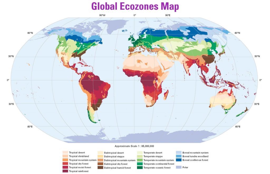
One way to learn about climate patterns around the world and the climate in a given region is to study the forest types present there. The Food and Agriculture Organization (FAO) of the United Nations uses temperature and precipitation to classify forests of the world.[1]
Climate Groupings
First, the FAO system looks at temperature to classify forests into five basic climate groupings, known as the Köppen-Trewartha domains. Those climate groupings are defined as follows:
Tropical – Mean monthly temperature of more than 18°C (64°F) all months of the year
Subtropical – Mean monthly temperature of more than 10°C (50°F) at least 8 months of the year
Temperate – Mean monthly temperature of more than 10°C (50°F) between 4 and 8 months of the year
Boreal – Mean monthly temperature of more than 10°C (50°F) between 1 and 4 months of the year
Polar – Mean monthly temperature of less than 10°C (50°F) all months of the year
The five domains fall in rough bands parallel to the equator. Because of the relationship of the Earth to the sun, the mean monthly temperature of an area depends greatly on the area’s proximity to the equator. Higher mean temperatures are generally found along the equator, which receives the most direct sunlight. The mean monthly temperature of an area is generally lower the farther that area is from the equator, with the lowest mean temperatures occurring at or near the poles.
Ecological Zones
After looking at temperature, the FAO system next examines precipitation patterns to further distinguish forest type. Within each of the domains are forests with different levels of precipitation, ranging from desert to rainforest. The FAO has identified 20 global ecological zones or ecozones, each with distinctive precipitation patterns and vegetation types. Higher elevations can affect temperature and precipitation, and so mountain forests are considered a separate ecozone within each forest domain. The Ecozones Defined student page summarizes the 20 ecozones and the Forests on the Ground student pages describe eight ecozones, with a sample forest type within each.
Discussion Questions
- How is climate different from weather?
- Name at least three ways that climate affects people’s lives.
- In the FAO system of forest classification, what factor differentiates the five climate domains? What secondary factor determines the 20 different ecological zones?
-
- Food and Agriculture Organization of the United Nations, Forest Department. 2001. “Approach and Principles of the FAO Ecological Zoning,” in Global Ecological Zoning of the Global Forest Resources Assessment 2000.
Food and Agriculture Organization of the United Nations, Forest Department. 2012. Global Ecological Zones for FAO Forest Reporting: 2010 Update.
- Food and Agriculture Organization of the United Nations, Forest Department. 2001. “Approach and Principles of the FAO Ecological Zoning,” in Global Ecological Zoning of the Global Forest Resources Assessment 2000.


