For the Teacher
The interaction of climate and geology helped sculpt and form our present-day landscapes. As the climate has changed through Earth’s history, the landscape has changed with it. Although you may study this change in any location you choose, one of the best areas to study it is the Great Lakes region of the United States. This area has molded and melded into the five lakes we know today as global temperatures warmed from a freezing ice age over time.
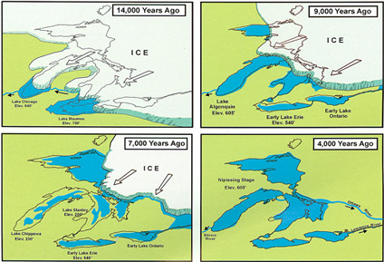
The Great Lakes were formed nearly 20,000 years ago when the Earth’s climate warmed and the last glacial continental ice sheet retreated1. The glacier, up to 2 miles thick, was so heavy and powerful that it gouged out the Earth’s surface to create the lake basins. Meltwater from the retreating glacier filled the newly created basins. Approximately 3,500–4,000 years ago, the Great Lakes attained their modern levels and area.

The Great Lakes were formed over the course of thousands of years as the glacier retreated.
Source: About Our Great Lakes. National Oceanic and Atmospheric Administration (NOAA) Great Lakes Environmental Research Laboratory. Originally from Living with the Lakes. U.S. Army Corps of Engineers and the Great Lakes Commission. 1999.
This dynamic region is an ideal place to study past and present climatic changes, and to make predictions for future climate change. However, feel free to have students examine your local area or other region. For more information about geological changes in the Great Lakes Region, check out the websites listed in Additional Resources for this activity.
This activity is designed as a project-based learning activity, a teaching method in which students gain knowledge and skills by working for an extended period of time to investigate and respond to a complex question or challenge. Most projects begin with a driving question—an open-ended question that sets the stage for the project by creating interest and curiosity.
With this classroom strategy, the activity is primarily student-led. The teacher’s role is to be a facilitator of knowledge, not the leader, content expert, or project director. There are several strategies for providing content resources for students, such as stations, expert group members, books, and note pages. For more information and resources on project-based learning, see the Buck Institute for Education website.
This is a cross-curricular project, incorporating science, social studies, and English language arts. Consider partnering with other teachers in these areas for help and support.
Formative assessments can be used whenever you feel they are appropriate throughout the course of this activity. You might conduct assessments at these points:
- After students have identified what they know and what they need to know for the project (steps 4 and 5)
- After expert groups have shared their research (step 11)
- During the time students are working in their project groups (steps 12–14).
As a general rule, the more time students are given to complete this activity, the more assessments should be incorporated to check on student comprehension and knowledge gain.
- “About Our Great Lakes: Background.” National Oceanic and Atmospheric Administration (NOAA) Great Lakes Environmental Research Laboratory ↩


